
Contrary to popular belief, the medieval world was surprisingly well connected much before the colonial powers arrived onto the scene. We often think the medieval “Dark Ages” was a homogenous age of ignorance and isolationism due to a lack of written records and horrific living conditions in some parts of the world, but that couldn’t be further from the truth.
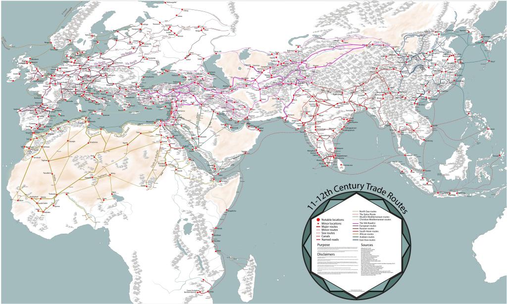
Intercontinental Trade Routes in the Medieval Era
During the medieval era when England and France were embroiled in a never-ending war, when their people were living in a poverty-stricken feudal society with nobles and peasants obsessed with witch trials, the era when the Holy Roman Empire (which was neither Holy, nor Roman, nor an Empire, as Voltaire put it) discouraged the common folk from being literate in order for them not to read and interpret the Bible their own way; during this era, the entirety of Europe had been well connected via trade routes established by the Vikings (8th – 11th Century) and later the mercantile Italian city-states, Marco Polo travelled the entirety of Asia and back (13th Century), and most importantly of all – it was the dawn of the Golden Age of Islam in the Abbasid Caliphate (8th – 13th Century). The reason for it being called the “Golden Age” is because the Abbasids gave a strong emphasis on preserving ancient knowledge and advancing the sciences, arts, philosophy, architecture and spearheading intercontinental trade between Asia, Africa and Europe.

The Islamic World at the time interacted frequently with the Vikings of Europe and connected the world via trade all the way from Spain (Al-Andalus, then occupied by the Caliphate) to China. Not only did the Muslims trade with the Chinese via the overland Silk Road, they also traded with the Indian coastlines and the East Indies, finding a route all the way across the Indian Ocean through the Straits of Malacca and onwards to the South China Sea. It’s not a surprise then that the first and most accurate ancient world map, the Tabula Rogeriana, was created by a Muslim cartographer from Al-Andalus by the name of al-Idrisi in 1154 AD.

Arab-Indian Trade Relations & The Rise of Trade Guilds
So how does all of this pertain to the tiny region of Anjuna? Well first, we need to gain some context on the cultural and socio-political dynamics of the Indian Ocean trade. During the 7th century AD, soon after the first dynastic Islamic Caliphate – the Umayyad Caliphate – came into being, the Arabian Sea trade flourished. Even before this, before the rise of Islam, the sea route to India using the monsoon winds was well known by merchants since the Greek and Roman times. Arabs, Jews and Persians would travel from Aden (in modern-day Yemen) to the Konkan and Malabar ports. However, this trade would not be very organized until the dawn of the 10th century when the Abbasid Caliphate established trade relations with the Rashtrakuta Empire in India, whom they considered their equals and had friendly ties with. This mutually beneficial alliance led to the rise of an institution known as “trade guilds”, referred to in inscriptions as Hanjamana in Konkan and Kanara coasts, and Anjuvannam in Malabar and Coromandel coasts. Initially, these comprised of people of a wide variety of West Asian ethnicities and religions – Arabs, Jews, Persians, Christians and Muslims.
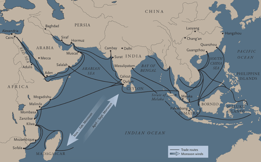
Returning to the Hanjamana, these guilds were highly internally regulated and were granted freedom by the Rashtrakutas to set up settlements along the coasts, enabling them to establish key port cities. Performing a round trip across the Arabian Sea twice a year with the ship technology of the time, with the added hindrance of piracy, was seen as a fool’s gambit, and so they settled and intermarried with the local population. Soon these merchants grew wealthy and prosperous from their overseas trade, and began to leverage their influence by providing donations to the local temples. As their influence and wealth grew, they gained a certain level of autonomy in the governance of the regions where they settled. This meant that a large portion of the ports on the West Coast of India were governed by these wealthy foreign merchants. Of course, this is not to say local trade guilds did not exist. In fact, the rise of the Tamil and Malabar trade guilds such as the Manigramam and Ayyavole-500 would cement the Chola dynasty as the masters of the Indian Ocean trade for centuries, their influence extending all the way across South East Asia.
Quite interestingly, the Shilaharas, who were feudatories to the Rashtrakutas, had a man known as Muhammad of Tajik/Arab descent as the governor of the port of Gopakapattana or Goa Velha, whom we know about because when the Kadamba King Guhalladeva crashed into this port on his way to the pilgrimage to Somnath, he was helped by Muhammad. The Kadambas were so impressed by the wealth and capability of this Muslim merchant family that when Jayakesi I shifted his capital to Gopakapattana, he made Muhammad’s grandson Saddam the mahapradhan or Chief Minister of the port city.

A major source of the wealth for these trade guilds and merchants was the perennial horse trade. Horses at the time were the equivalent of fighter jets today, they were immensely valuable and owning higher quality horses such as those from Arabia could turn the tide of war. This fact carries on throughout the medieval times, ending only in the early 1600s when cannons and artillery became commonplace.
The ethnic and cultural milieu of the West Asian traders would diminish into a purely Arab Muslim gentry as the years went by, most likely due to the reforms made in the later Islamic Caliphates which encouraged conversions by providing tax concessions on trade only to Muslim merchants. Either way, these communities were now deeply entrenched into the culture and society of early medieval Goa. After the end of Kadamba rule and the consequent tug-of-war for Goa between the two major powers – the Bahmani Sultanate and the Vijayanagara Empire, most of the wealthy Muslim merchants either migrated to other port cities (like Dabhol, Chaul, Bhatkal, Honnavar, Connonore and Mangalore) where they had better safety and freedom to trade, or to the inner cities of the Sultanate. However, we mustn’t forget that these early Arab merchants have etched a lasting legacy on the historical and cultural landscape of Goa.
Anjuna – A Port of Significance
Anjuna was one such settlement of these merchants, the name thought to be derived from Hanjamana, the Persian word for a collective, in this case a guild. Their main settlement must have been concentrated along the coastline, the inner areas like Vagator and Siolim being mostly uninhabited at the time due to wildlife. Hence, their presence would most likely be in the regions along the Chapora River, in both Bardez and Pernem.

Chapora, located at the mouth of the Chapora River to the north of Anjuna, has quite an attractive natural harbour and several inland harbours, so one could imagine that the Arab merchants that settled in the region used it to their advantage to set up early makeshift ports. One such port likely existed at the foot of the later-built Chapora Fort, which would be converted into a stone jetty by the Portuguese, and another is the lesser-known minor inland port of Arabó.
Believed to be named after the Adil Shah of Bijapur himself (Shahpura, or the city of the Shah), it houses the grand Chapora Fort atop a hill, a construction which is now in ruin. The original structure was most likely built by the Bahmani Sultanate to oversee the trade that took place along the natural harbour below. Arab dhows frequented this port to sell commodities such as dates, rice, oil, timber and cloth; and there also existed a ship-building yard nearby.

After the capture of Bardez by the Portuguese, Chapora would turn into the frontier against the Bijapur Sultanate, and consequently its value as an important trade hub would diminish. The Portuguese renovated the Chapora Fort in 1617 for the purpose of defending the northern frontier, naming it Forte de Santo António de Chaporá, however it would fall twice to the Marathas. After the Novas Conquistas, or New Conquests, the border shifted to Tiracol, and so Chapora no longer retained its importance as a line of defense.
In 1857, its role as a natural harbour would return briefly, with the construction of an small extension to the Fort (at the foot of the hill) which housed the Alfandega de Chaporá, or Customs House of Chapora, and an adjoining residence of the Capitão do Porto. A stone jetty was also built at the time, which still exists to this day. This port was used famously by Caetano Diogenes Mascarenhas who conducted trade with Daman, dispatching pattimars with rice and coconuts from his vast ancestral lands. Soon, he amassed a fortune and came to be known as “Caetano Coco”. Due to his service in providing help to Daman during a time of famine, he was made the Visconde de Damão.
The importance of this port would wane over the years, and soon the Alfandega would close down as well, the jetty now mainly used for fishery and home to a fish market.
Arabó – A Tiny Village Steeped in History
Likewise, on the opposite side of the Chapora River in the taluka of Pernem, the little village of Arabó was also a port which likely had a sizeable population of Arabs – due to the fact that its name is derived from the name of the people, and also from the oral traditions and stories passed down through the generations.
In the same vein as Chapora, Arabó too once had a minor port where Arab dhows came to trade, with a small fort adjacent to it which is said to have housed 7 cannons. Little is known about the commerce in this region, but it is said that the Desai House that exists there was owned by Muslim merchants in the past, whose origins might have been from Iraq.

The house was renovated in 1890, however a flagpole left behind by the earlier occupants still remains fixed in place to this day due to a promise made by the Desais of Arabó to the merchants. They would allow the Muslim community of Arabó to venerate it every Muharram and on a special festival day known as Urus where the people pay respects to a Pir or Sufi saint that passed away in the village. The flagpole or bherag was a relic considered sacred to the Arab traders. The fascinating history of the tiny village of Arabó and its traditions truly deserves an entire article of its own.
Now nothing more than sleepy villages, the heritage that once existed in these places has all but disappeared. The harbours once bustling with merchants from across the Indian Ocean now lie dormant, only traditions and legends have stood the test of time. Despite this, it is humbling to realize that we were once a part of a millennium-old web that stretched halfway across the globe, a portion of which has been etched permanently into the names of our beloved villages.
Sources / Further Reading:
- “Anjuna: Profile of a Village in Goa”, Teresa Albuquerque
- “Village Anjuna: Vignettes from Goa”, Domnic P. F. Fernandes
- “Anjuvannam: A Maritime Trade Guild of Medieval Times”, Y. Subbarayalu
- “Anchors from Goa waters, Central West Coast of India: Remains of Goa’s overseas trade contacts with Arabian countries and Portugal”, Sila Tripati, A. S. Gaur and Sundaresh
- “Describing a lost camel – Clues for West Asian mercantile networks in South Asian maritime trade (10th– 12th centuries CE)”, Elizabeth Lambourn
- “Desai de Arabó”, Rajan Parrikar
- “Why Hindu Kadambas Allied With Muslims”, Nandkumar Kamat
- “The unique Urus of Arabo”, Sanjeev Sardesai
- “Of Settis and their Deities: Historicising the Mercantile Communities and the Commercial Culturescape of Pre-colonial Goa”, Pratima Kamat
- “Muslim Merchants in Pre-Modern South Western India”, Nagendra Rao
- “Goa Through the Ages: An Economic History Vol. 2”, Teotónio de Souza
- “Forte de Santo António de Chaporá”, fortalezas.org
- “As Fortalezas de Goa e suas legendas, Oriente Português, no. 19-21″, Ricardo Michael Telles (Portuguese)
- “First Global Village? The Story of Anjuna”, Times of India
- “Maritime India: Trade, Religion and Polity”, Teotónio de Souza

One thought on “Anjuna, Arabó & The Interconnectedness of the Medieval Indian Ocean”