“All roads lead to Rome”, so goes the saying that captures the extent of the once mighty Roman Empire. The Romans during their peak had built large networks of roads that stretched all across their Empire, from London to Damascus. This wasn’t just them being indulgent as the most powerful Empire at the time however, instead it was a way of connecting all the provinces to their capital, Rome, for efficient trade and administration. Before the construction of these roads, it would have been nigh impossible to travel between the distant provinces by horse, due to the presence of thieves and highwaymen. The roads, on the other hand, were always patrolled by Roman guards called stationarii, who protected caravans and travelers who journeyed across these roads.
So why am I bringing up Rome in an article about Goa? Well, the idea I’d like to put across is that roads in the past were primarily built to help connect faraway lands, provide safe passage, boost trade and most importantly to consolidate power over those lands. The region that consists of present-day Goa, up until the Kadamba Dynasty, never really had anything in the sense of roads. This was partially due to the fact that this region was never really the center or capital of any Kingdom or Empire, almost always being a minor part of a province on the periphery of a Kingdom, where it was much more cost-efficient to travel to and fro via ship rather than building roads to it.
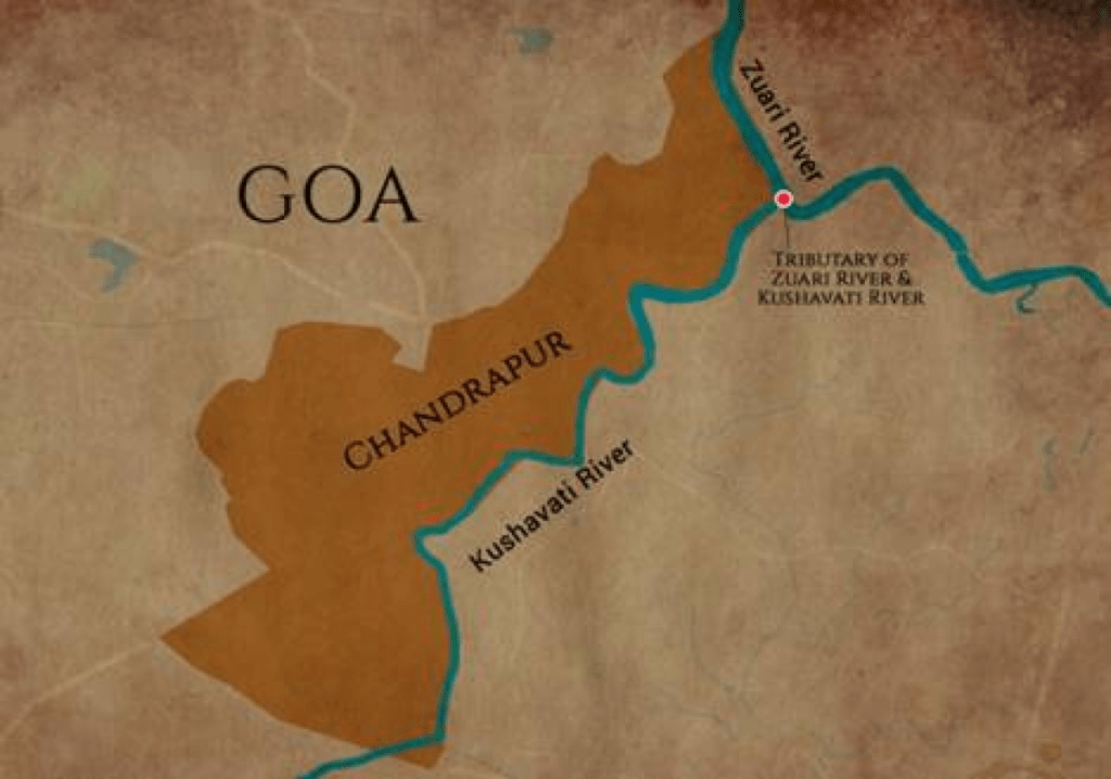
This changed, however, during the reign of the Kadambas of Goa, who shifted their capital from Chandrapur (present-day Chandor) to Govapuri, later Gopakapattana (present-day Goa Velha), partly due to the silting of the Kushavati River and partly to extend their naval and trade power. They defeated and subdued the Shilaharas in the entire Konkan region stretching from Uttara Kannada in the South to Thane in the North, but chose to keep their capital in Goa.
Govapuri already had a booming economy under the South Shilahara rulers during the 11th century AD, owing to the fact that it was administered by an extremely wealthy merchant known as Mudamod (or Muhammad) who had gained autonomy over the port city, and also due to an extensive horse trade with the nanadesis or foreigner merchant guilds who traded with the port cities of South India up until the 13th century AD. This horse trade would come to be a recurring factor in the prosperity of Goa under later rulers, even up until the Portuguese.
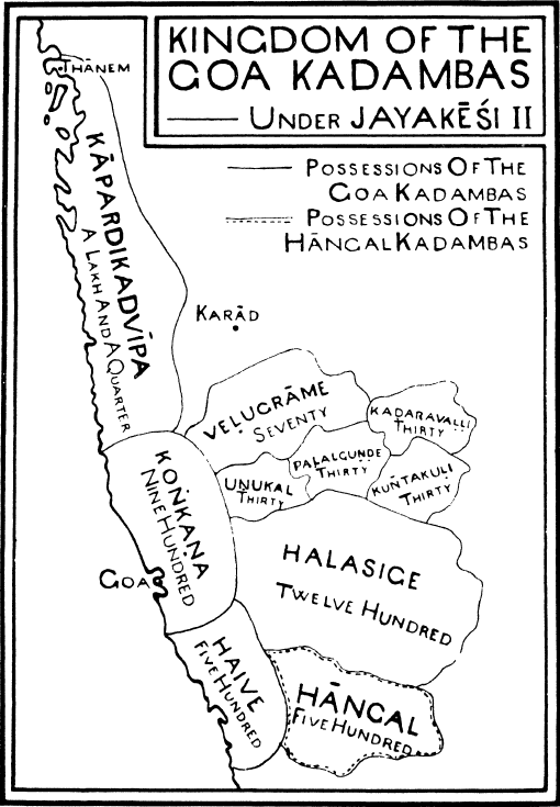
The Goa Kadamba Dynasty reached its height during the reign of the first five kings, stretching from Thane to Uttara Kannada, and likewise the port city of Gopakapattana flourished, having trade relations with the likes of Simhala (Sri Lanka), Kalah (Kuwait), Zangavar (Zanzibar), Paandya (Tanjore), Kerala, Gauda (Bengal) and Gurjara (Gujarat). Several of the Goa Kadambas even took upon themselves the title of Konkan Chakravarti, “Ruler of the Konkan” and Paschima – Dakshina Samudradipathi (Lord of the Western and Southern Seas).
Roads were already built from Chandrapur, the first capital, to Govapuri under the rule of the benevolent King Shashtha-deva II, as attested by the following inscription,
“Roads that led to Shashtha-deva’s capital were always filled with a concourse of people who were going to or returning from his capital.”
But it would be under the patronage of the next King, Jayakesi I, where Govapuri would come to be the capital Gopakapattana.
“His arm being the resting place for the embraces of the goddess of bravery, he, most energetically illuminating the world with the abundance of his fame, spotless as the tremulous rays of the moon, made his firm abode in the city of Gopakapattana.”
This shift in capital would come to define Goa’s prosperity for centuries to come, and it would be here that the great Rajvithi would be built.

The Rajvithi, or Royal Road, must have looked grand during the zenith of the Kadambas. A paved stone pathway 20 meters wide and 8 km in length defined the limits of this ancient highway within the city. It is said that large temples and tanks (tollem) dotted the road on all sides within the confines of the port city that covered Agaçaim in the South, Neura in the East, Karmali in the North and Talaulim in the West. This decadent road stretched from the dock of the Gopakapattana port at what is now Agaçaim Beach, through the villages of present-day Goa Velha, across the hillocks of Pilar, terminating at Ellapuri (present-day Ella and Old Goa), whereupon it would continue further after a short boat ride to Divar, all the way up to Naroa and Bicholim, and further across the ghats towards Karnataka.

And not just this, it also had several streets, mountain passes and bandhs that branched out and connected other parts of the land like the harbour at Velakula (Neura) or the hamlet of Kadambhalli (Karmali/Carambolim). Dakhti bidi divided the city into districts, whereas local paivatt connected the Rajvithi to distant villages like Calapur (St. Cruz), Panjanakhani (Panaji) and Raibandhar (Ribandar). It would truly have been a sight to behold. And rightly so are we told by an inscription,
“The street of his (Jayakesi’s) capital was completely filled with the palanquines of his pandits, constantly passing, the poles of which were covered with jewels, and inside which were quivering the golden ear-rings (of their owners).”
And it wasn’t just its beauty that made it a wonder to behold. You see, the road was also designed for a very practical purpose. Being a major port city for the erstwhile Kingdom, all the ships from faraway lands would disembark at Gopakapattana. This meant that the goods would have to be carried across long distances to all the corners of their Kingdom. So, just like the Romans, maintaining a road meant reducing losses by theft.

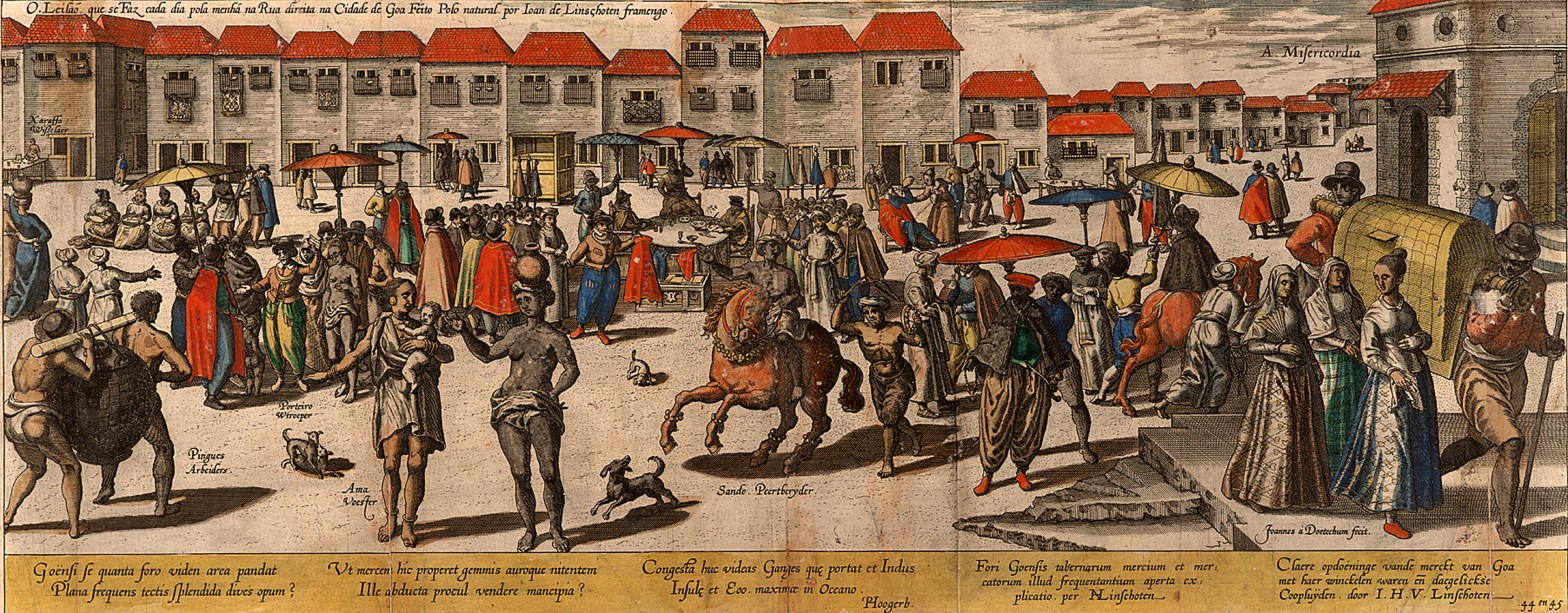
Today, all that remains of this once magnificent construction are the trodden paths that were used by people centuries after the demise of the Kadambas, to travel by foot for their pilgrimages from Salcete to Old Goa. Parts of this road were also made use of extensively by the later Bahmanis, Vijayanagaras and the Portuguese. The Portuguese even famously used this very road as their market road, as they found it perfectly linear for stalls to be set up on either side. It is, then, truly a testament to the ingenuity of these streets that we still walk upon parts of it today, altered only in name to Rua Direita.
Sources / Further Reading:
- “The Kadamba Kula: A History of Ancient and Mediaeval Karnataka”, George M. Moraes
- “The Role of Merchant Guilds in the Urbanization of South India”, K.P. Velayudhan
- “Goapuri & Velha Goa, A Tale of Two Cities – Walking the Labyrinths of History”, Mario Cabral e Sá
- “The Heritage of Govapuri: A Study of the Artifacts In and Around the Pilar Seminary Museum”, Fr. Cosme da Costa
- “Reconstructing the Urban Maritime History of Goa: A Study of the Port-Capitals of Chandrapur, Gopakapattana and Ella”, Alvita M. D’Souza

Great article!
LikeLike
Thank you! I’m glad you enjoyed it 🙂
LikeLiked by 1 person
Very much!! 🙂
LikeLiked by 1 person